
RECLAMATION INTELLIGENCE
Walk into COR Part 2 with a multi-year record
Northeast British Columbia · BCER ESSG v1.1
ESSG monitoring runs until every performance metric passes at once. With plot-based assessment, issues tend to surface one cycle at a time. Drone-based monitoring gives you the full spatial picture earlier — so mitigation is planned once against the whole site, and closure arrives with a documented record rather than a final snapshot.
CONTEXT
The ESSG, in plain terms
The Ecologically Suitable Species Guideline (ESSG) sets BCER's minimum expectations for short-term reclamation performance metrics on Crown forested land in Northeast BC. For sites reclaimed in 2024 and beyond, those metrics must be achieved and reported as part of a Certificate of Restoration (COR) Part 2 application — now formalized as the Restoration Assessment Form under the 2026 Site Remediation and Reclamation Manual.
It's a practical framework — but operators are still working out how to assess it efficiently across a portfolio of sites, document trajectory over multiple years, and meet the regulator's spatial reporting requirements. That's where we come in.
THE SPATIAL GAP
Late discovery tends to compound
Standard field assessment samples what's at each plot. The space between plots — where most of the site lives — stays unobserved. That gap is where issues establish unseen, and where the monitoring cycle tends to stretch.
The downstream consequence is a pattern, not a specific timeline. With field sampling alone, issues surface as plots happen to intersect them — typically a finding or two per cycle, each tending to drive its own response. With a drone layer added, the same issues are visible together in a single dataset, and mitigation can be scoped once against the whole picture rather than reactively across successive cycles.
Every site is different. Some close cleanly on the first cycle; others sit in monitoring for years. What the spatial layer reliably changes is the pattern of discovery — which is upstream of everything else.

WHERE DRONE DATA ADDS VALUE
Three improvements to the workflow you already have
We're not claiming drone data replaces field methods, or that it unlocks a regulatory shortcut. It adds three specific things — each aligned to a mechanism ESSG explicitly permits, and each hard to get any other way.
At planning and baseline, a full-site picture lets you shape the approach while it's still open — where to place species, which areas need soil work, what to correct before it sets the site's trajectory for years. Changing the plan at this stage costs almost nothing.
Your leverage over the outcome shrinks every season after. The same fix later means a return mobilization, replanting into established competition, or defending a marginal metric at closure. Early, wall-to-wall data is the cheapest, highest-leverage input you can add.
Drone data surfaces density gaps, invasive patches, erosion features, and bare ground across the whole site — not just inside monitoring plots. Issues are seen when they're small and localized, often one or two seasons before they'd surface in routine field assessment.
Earlier detection means the treatment program is planned once, as a coordinated intervention, rather than as reactive trips across multiple cycles.
ESSG explicitly allows the QRS to argue site acceptance based on trajectory — evidence a site is moving in the right direction, even where a single-year metric sits close to threshold.
Year-over-year drone imagery is that evidence. Invasive cover 15% → 10% → 8% is a defensible trajectory. Plot data alone can't make that case.
HOW IT WORKS
Four phases, one record
Each phase builds on the last. By closure, you have a single, spatially referenced, multi-year record ready to drop into your COR Part 2 package.
OUR APPROACH
Remote sensing and fieldwork, working together
Not every metric belongs in the air. Not every metric belongs on the ground. A credible ESSG program knows where each tool earns its place.
| Lead method | What it covers | ESSG metrics |
|---|---|---|
| Remote sensing ledMetrics we automate | Spatial, structural, and cover-based metrics that drone LiDAR and imagery measure directly, wall-to-wall, across the entire site. Seedling detection & counting, canopy & woody cover mapping, bare ground & erosion mapping, invasive species identification, terrain & microtopography modelling. | Terrain · Stability & erosion · Vegetation cover · Woody density · Bare ground · CWM |
| ComplementaryWhere RS and field work hand-in-hand | Metrics where drone data flags priority areas and directs field effort, and field observations validate and refine remote sensing outputs. | Plant community · Invasive & noxious species · Seedling survival · Organic matter |
| Field ledWhat still requires a shovel | Soil properties and species-level identification need direct observation. Remote sensing can guide fieldwork to where it matters most — reducing time onsite, not replacing the visit. | Soil depth · LFH · Compaction · Rooting zone · Species ID |
DELIVERABLES
What shows up after a flight
Tangible products, in formats your team already uses — typically within weeks of the flight, not months. Nothing lives in a proprietary viewer your consultant can't open.
Full-site optical coverage at sub-cm resolution (defined for each project). Foundational layer for extraction of all other products.
Conifer and deciduous stems per hectare, keyed to ESSG woody density thresholds. Validated against field plots.
Polygons with species ID where visually identifiable, flagged for field confirmation.
Spatial flags for targeted field attention and corrective action planning.
Slope, microtopography, drainage — supporting site stability and landform metrics.
Web dashboard for your QRS and team; shapefiles and GeoPackages for your GIS.
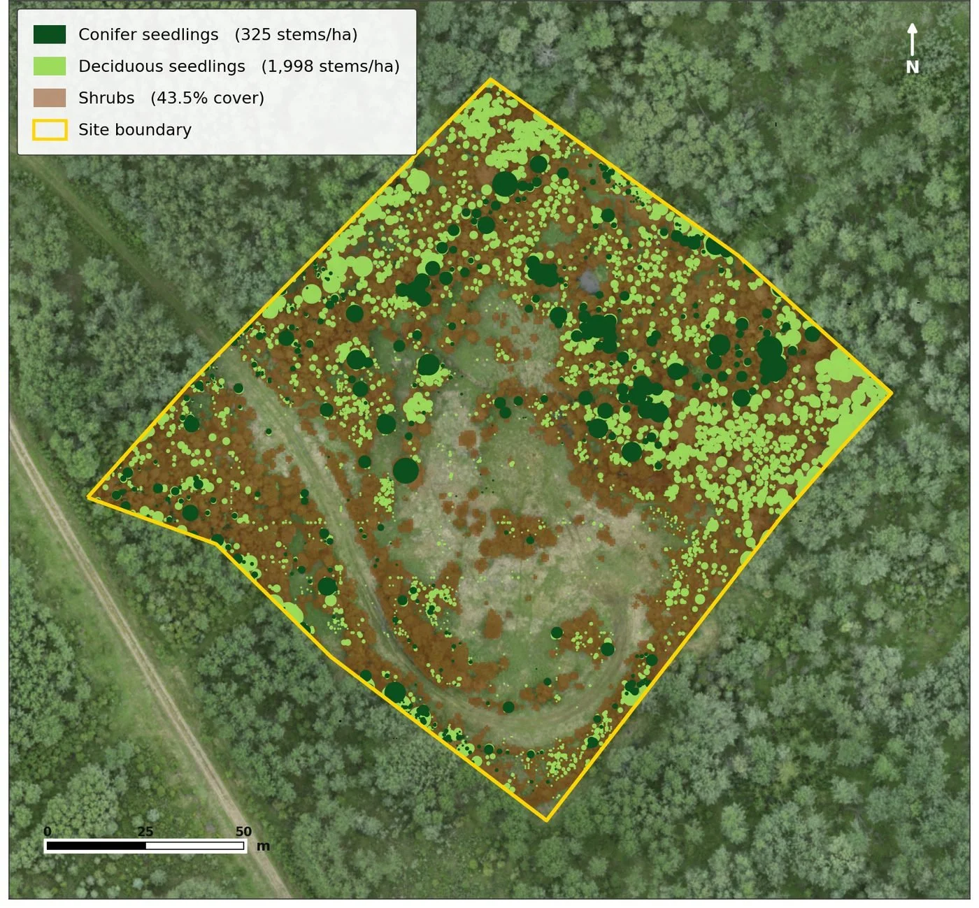
Every woody stem is detected and classified, then aggregated into the ESSG 30 m assessment grid. Each cell is scored against the 800 stems/ha minimum, so a shortfall shows up as a located polygon — not a plot that happened to miss.
Detection is validated against field plots: conifer seedlings 20 cm and taller are found at roughly 90% recall, so the counts hold up under scrutiny.
OUR APPROACH
Remote sensing and fieldwork, working together
Not every metric belongs in the air. Not every metric belongs on the ground. A credible ESSG program knows where each tool earns its place.
GET STARTED
Let's talk about your sites
A first conversation is no-cost and usually takes 20 minutes. Bring your sites, your timelines, and your closure questions — we'll bring the rest. We'll tell you honestly whether drone monitoring is a good fit for your portfolio, or whether traditional assessment still makes more sense for your situation.